Periferia-Periphery
by Maurizio Angelucci - Foto-Photos by Nicoletta Di Ciano
L’immediata periferia – Lanciano’s Immediate Suburbs
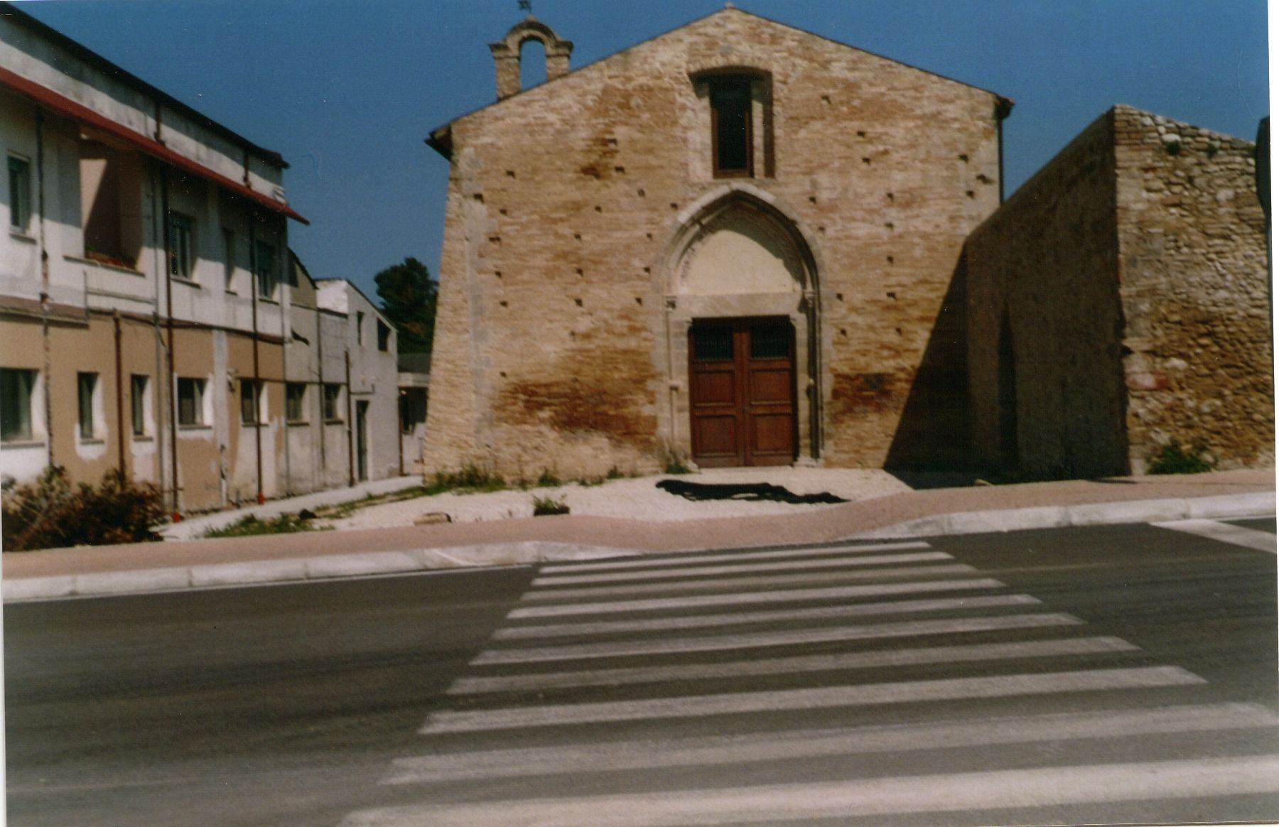
The Mancino quarter is to the west and 100 metres far from Corso Trento and Trieste. It is still developing along and around Via del Mancino, ending with a steep descent leading to the city outskirts, and with many streets as the long Via del Verde and other ones full of modern palaces and dedicated to the most important Abruzzo’s rivers. In the quarter there is also the zone of Santo Spirito, so called for the ancient church whose construction was begun in 1293 in then contrada Bordella, by the will of the abbot Onorio of the order of Morrone. Another evidence of its existence is the Rationes Decimarum of 1308, number 3468 and 3505, where it was spoken about the Monasterium S. Spiritus ordinis Murronensium. It has been recently restored after years of neglecting and it shows a surprising simplicity in its whole brick structure, the doorway, the lunette and the bell-tower. The history of the church of Santo Spirito has many traditions according which it was a convent of hermits, into an ideal place for a solitary and contemplative way of living in that countryside area of the medieval Lanciano. Among several traditions it detaches that one about the stay of the hermit Pietro of Morrone, then Pope Celestino V in 1294, who discharged after six months to escape to the followers of the successive Pope Bonifacio VIII. In 1654 the convent was abolished and it passed to private persons that gave shelter to some enclosed nuns. The church is still closed to the cult but it is he seat of a museum of the Abruzzese transhumance. There is also a church dedicated to the Holy Hearts of Jesus in the quarter, dating to the beginning of the 20th century, never written in Lanciano’s books, with one nave, a high altar restored in 1985, and the statues of St. Joseph and the Madonna, a 1945 crucifix, and an ancient picture representing an apparition of Jesus to St. Margaret Alacoque.
Shortly before the Mancino quarter, just after the present Corso Trento and Trieste, there was the convent of Fathers Carmelitani, built in the XVI century, with the church of the S. S. Crocifisso (worshipped as that one of S. Mauro) that was pulled down in 1939. Some Lanciano’s history books make confusion between this convent and the church of the Madonna del Carmine at contrada Villa Carminello, which didn’t exist in the XVI century and was instead built in 1904 (according to my first dating in Contradando per Lanciano)
La secolare zona Fiera, il quinto quartiere storico di Lanciano, inizia subito dopo la parte finale del Ponte Diocleziano e fino all’inizio del ventesimo secolo era tutta campagna con delle antiche case intorno al Corso Bandiera che prende il nome dalle bandiere, cittadina e del regno, che il Mastrogiurato issava quando dichiarava aperte le gloriose fiere medioevali. Ciò avveniva alla fine di Corso Bandiera, nell’area de I Viali, il principale posto di passeggio cittadino dove i lancianesi fanno “lo struscio” (percorrendolo avanti ed indietro come un proseguimento di Corso Trento e Trieste). Il quartiere Fiera si è ingrandito dagli anni 1925-30 con la costruzione delle prime case popolari nella grande Piazza della Vittoria (con riferimento alla “felice” conclusione della prima guerra mondiale) e con la costruzione del Viale delle Rimembranze, che fiancheggia la bella Villa Comunale, il parco cittadino costruito nel 1925-28, che termina in un’area intorno ad un caratteristico spazio chiamato “il quadrato” per la sua forma.
The secular Fiera zone, the fifth historical quarter of the medieval Lanciano, is soon after the final part of the Ponte Diocleziano and until the beginning of the 20th century was simply a countryside area with ancient houses around the present Corso Bandiera that takes its name from the flags, citizen and of the reign, which the Mastrogiurato hoisted when he opened the glorious city medieval fairs. That happened at the end of Corso Bandiera, in the area of I Viali, that is the main local boulevard where local people are making ‘lo struscio’ (walking up and down along it as a continuous walk coming from Corso Trento and Trieste). The medieval Fiera zone was expanded in 1925-30 with the construction of the first tenement houses in the large Piazza della Vittoria (Victoria Square, to recall expressly the ‘happy end’ of the First World War) and the following development of the long Viale delle Rimembranze (Memorial Avenue), which is bordered the beautiful Villa Comunale, the city park built in 1925-28, while it ends in an inhabited zone around a characteristic square area called `il quadrato' (the Square) for its shape.
Ad una cinquantina di metri da “il quadrato”, da una strada laterale si vede il convento di S. Antonio da Padova e, giunti ad un semaforo, c’è l’estesa Via per Fossacesia che termina in un incrocio con semafori e delle strade che conducono alle città del mare e delle montagne ed al più grande e popoloso quartiere cittadino, S. Rita. Il convento di S. Antonio da Padova si sviluppò sull’antico sito della chiesa di S. Angelo della Pace, che fu costruita intorno al 1430 per commemorare la riconciliazione fra Lanciano ed Ortona, in lotta per il possesso del porto di S. Vito, ratificata con un atto di pace il 17 febbraio 1427 dal giurista e poi francescano S. Giovanni da Capestrano (al santo è dedicata una strada parallela a Via per Fossacesia).
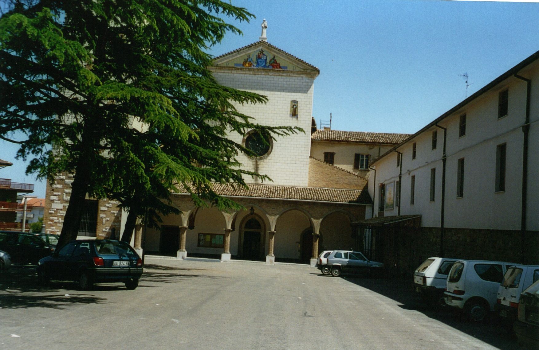
About fifty metres from ‘il quadrato – the square’, from a side road you’ll see the convent of S. Antonio of Padova (St. Anthony of Padova) and, near a traffic-lights, there is the extending Via per Fossacesia while, in its final part, you’ll reach a cross-road with another traffic-lights and some roads leading to the towns of the sea and of the mountains, and to the greatest and inhabited city quarter, S. Rita. The convent of S. Antonio of Padova has been developing on the ancient site of the church of S. Angelo della Pace, which was built around 1430 to remember the peace between Lanciano and Ortona, which were fighting for the port of S. Vito, ratified with an act of peace on February 17 1427 by the jurist and then Franciscan Friar S. Giovanni of Capestrano (to the saint is dedicated a parallel street to Via per Fossacesia).
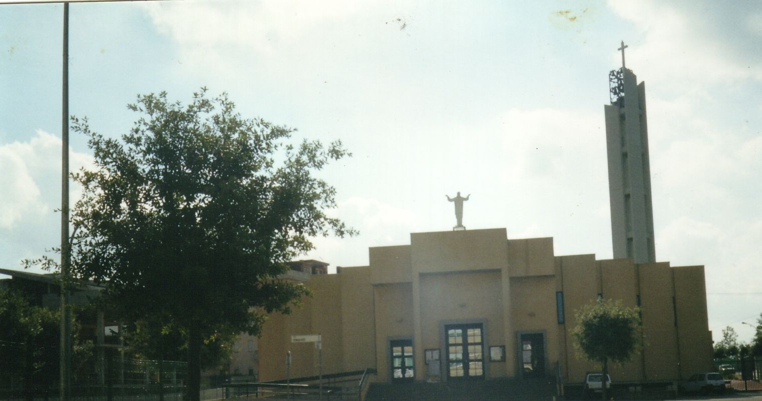
S. Rita, il quartiere più esteso e popoloso di Lanciano (circa 7.000 abitanti su 36.240), è sorto nel 1978 nella zona a sud-est e a 2 Km dal centro cittadino, ai confini delle contrade Iconicella, Villa Martelli, Villa Stanazzo e Villa Carminello. Il quartiere è stato dedicato a S. Rita nel maggio 1996 e fino ad allora era noto come ‘zona 167’, con riferimento alla Legge nazionale del 18 aprile 1962, n. 167, “Disposizioni per favorire l’acquisizione di aree per l’edilizia economica e popolare”, poi modificata ed integrata dalle leggi 21 luglio 1965, n. 904 e 22 ottobre 1972, n. 865, che ispirò gli amministratori locali nel 1973, quando fu approvata una variante generale al Prg che prevedeva la costruzione di quello che sarebbe diventato il quartiere cittadino più grande e popolato. Trovandosi alla periferia della città la “zona 167” era anche affettuosamente, e non ridicolmente, chiamata “satellite” dai lancianesi. La sua realizzazione certifica la lungimiranza dei politici che hanno risolto il problema di alloggi confortevoli a prezzi popolari ad un quinto della popolazione lancianese, in gran parte proveniente dai quattro quartieri del centro storico (Lancianovecchia, Civitanova Sacca e Borgo). Lo spostamento di molti cittadini ha provocato una vera e propria rivoluzione culturale e di vita, per nativi e residenti del centro storico cui erano morbosamente affezionati, con una sensibilità quasi egocentrica derivante dalle storie di generazioni perennemente protagoniste nella conservazione fondamentalmente immutata del costruito medievale di Lanciano. Ma il corpo sociale lancianese comprese che in una città così ricca di storia i bisogni e le richieste di trasformazione ed evoluzione del tessuto urbanistico e della qualità della vita erano arrivati ad una fase storica irreversibile dello sviluppo, urbano, abitativo e culturale di Lanciano, che ha saputo preservare in tanti secoli le caratteristiche originarie del proprio centro storico con delle intelligenti varianti urbanistiche con le quali ogni volta la città si rimodellava su se stessa di pari passo col rispetto della sensibilità e delle esigenze di vita dei suoi abitanti. Agli albori della vita del quartiere la S. Messa e gli altri incontri religiosi avvenivano in un salone, oggi diventato la Sala della Cultura ed attigua all’attuale chiesa dedicata a Santa Rita e consacrata allo Spirito Santo il 30 aprile 1995.
S. Rita, the most extensive and inhabitated quarter of Lanciano (with approximately 7,000 inhabitants on 36.240), rose in 1978 in the zone to the south-east and 2 Km from the city centre, to the borders of the contrade Iconicella, Villa Martelli, Villa Stanazzo and Villa Carminello. The quarter was dedicated to S. Rita in May 1996 and until then it had been as `167 zone', with regard to the national Law n.167 of April 18 1962, "Dispositions to promote plans for building of popular houses', then modified and integrated by the law n. 904 of July 21 1965 and n. 865 of October 22 1972, which inspired the local administrators in 1973 to pass a general varying to the town planning to forecast the construction of what it would have become the largest city quarter. Being to the periphery of the city, the '167 zone' was also lovingly called, not in a ridiculous way, 'satellite' by the lancianesi. Its realization attests the far-sightedness of the politicians who have resolved the problem of comfortable lodgings under price to one fifth of Lanciano's population, while most of them were coming from the four quarters of the historical centre (Lancianovecchia, Civitanova, Sacca and Borgo). The displacement of many citizens was a sort of a cultural revolution for native and residents very fond of their historical centre, with a nearly self-centred feeling deriving from histories of generations since and for ever engaged in leading part to protect Lanciano's medieval shape. But Lancianesi became conscious that, in such a city rich in history, needs and demands for a transformation and an evolution of its urbanistic profile and their way of living were now an irreversible historical phase of the urban, inhabiting and cultural development of Lanciano, which had been able to preserve its historical centre's original characteristics for centuries, with very clever urbanizations through which every time it modernized and adapted itself, always keeping up with the respect of its citizens' feelings and life's requirements. At dawn of the quarter's birth, Holy Mass and other religious meetings took place in a large hall, today known as Culture's Room and contiguous to the present S. Rita Church that was consecrated to the Holy Spirit on April 30 1995.
La zona di S. Pietro. Il primo piano regolatore cittadino del 1879 aveva considerato la possibilità dell’espansione di Lanciano verso Viale Cappuccini, ma il progetto era stato accantonato per mancanza di fondi. Nella difficile e lenta ricostruzione dopo la seconda guerra mondiale, la vasta zona oggi nota come S. Pietro andò sviluppandosi lungo ed intorno alla grande strada che porta a Castelfrentano, Viale dei Cappuccini costruita dal 1810 al 1850, e le grandi strade parallele di Via Belvedere, dove c’e lo Stadio costruito nei tardi anni del decennio del 1960, e Via Martiri 6 Ottobre, dedicata ai martiri locali del 1943. L’attuale quartiere S. Pietro era una zona secolare che faceva parte dell’antica contrada Follani, la quale si estendeva da subito dopo la chiesa di S. Chiara con alcune terre documentate nel XIV secolo nella contrada Piana di S. Bartolomeo, con l’omonima cappella sul cui sito fu costruita, verso la fine del XVI secolo, il convento di S. Bartolomeo, abitato ed officiato dai Frati Cappuccini che oggi vivono nella nuova chiesa di S. Pietro. Intorno al 1950 la zona stava popolandosi col favore delle migliorate condizioni economiche e a furor di popolo si cominciò a pensare alla costruzione di una grande chiesa, per esaudire i bisogni religiosi di questa zona che andava sempre più caratterizzando la città di Lanciano. C’era a quei tempi una chiesetta dedicata a S. Pietro, situata proprio alla metà di Viale Cappuccini, nel largo prospiciente la scalinata che porta all’attuale chiesa dedicata allo stesso santo. Non ci sono notizie storiche di quella che era una piccola cappella rurale, chiusa al culto ed officiata ed affollata solo durante la festa di S. Pietro il 29 giugno, e non è stata conservata nessuna foto, ma secondo le reminiscenze di alcune persone essa aveva qualche somiglianza strutturale con la chiesa di contrada S. Maria dei Mesi. Essa fu demolita quando l’8 settembre 1954 fu istituita la parrocchia e fu sostituita dalla nuova ed attuale chiesa, costruita in uno stile moderno nel 1956 ed aperta ai fedeli l’anno dopo.
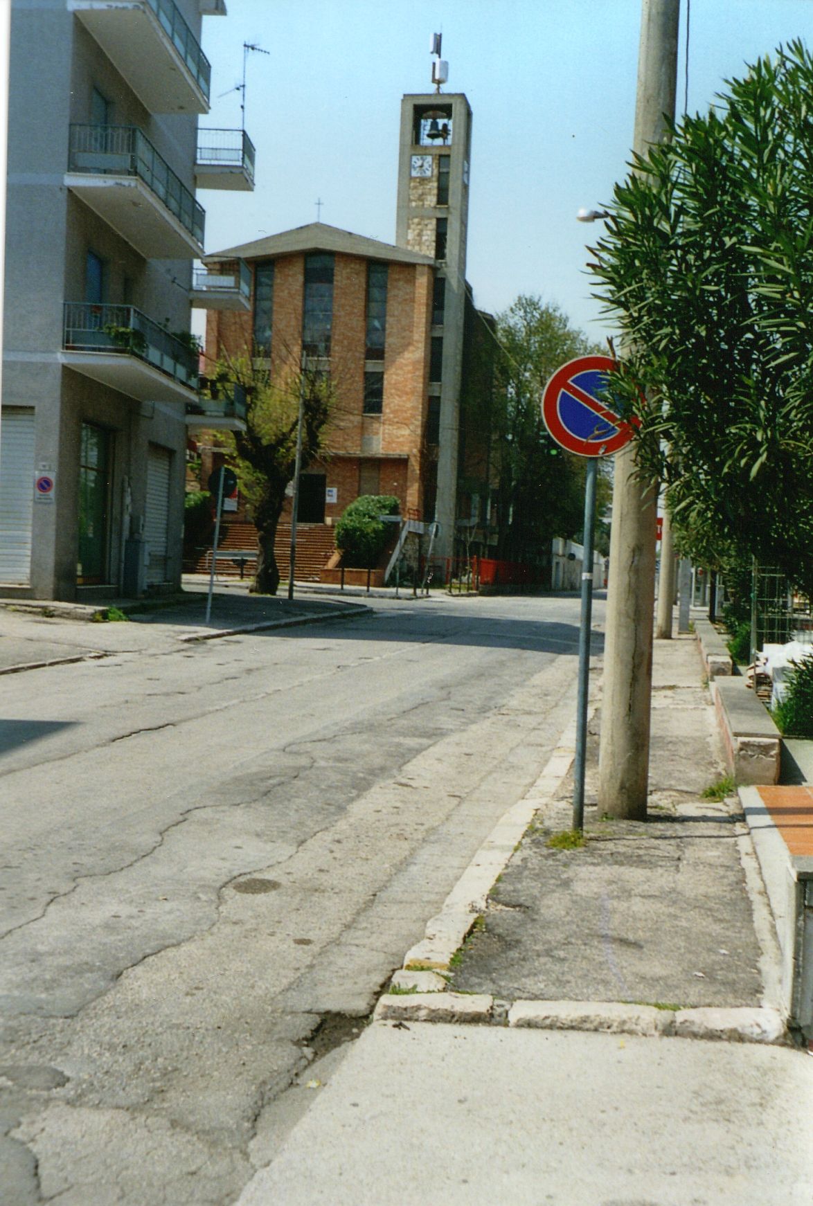
S. Pietro’s zone (St. Peter). The first 1879 town planning of Lanciano had considered the possibility of the expansion of the city towards Viale Cappuccini, but this part of the general plan had been rejected for financial difficulties. In the years following the Second World War, when the reconstruction of the town was very hard and slow, the immense area today known as S. Pietro has been developing along and around the main road leading to Castelfrentano, Viale dei Cappuccini, built from 1810-1850, with its big parallel roads of Via Belvedere, where is the Stadium built in late 1960s, and Via Martiri 6 Ottobre, dedicated to the local martyrs of 1943. The actual S. Pietro quarter was a secular zone making part of the ancient contrada Follani, which extended soon after the church of S. Chiara with a portion of it documented in the 14th century as the contrada Piana of S. Bartolomeo, with a homonymous little chapel on which site was built, towards the end of the 16th century, the convent of S. Bartolomeo, inhabited and officiated by the Cappuccini friars who, nowadays, are living in the new church of S. Pietro. Around 1950, the zone has been growing in favourable economic conditions and, by great insistence of people, it was began to think about the building of a new big church, to satisfy the religious needs of a growing and populating area that was more and more characterizing the town of Lanciano. There was then a little church dedicated to St. Peter, sited just in the middle of Viale Cappuccini, in the little square before the stairway leading to the actual church consecrated to the same saint. There aren’t any historical news about that first rural chapel, not in use and crowded only on June 29, St. Peter’s day, and it doesn’t exist any photo but someone compared it to the church of the contrada S. Maria dei Mesi. It was demolished when, on September 8 1954, the parish was elevated so that the new and actual church was built in 1956 in modern style and opened to the cult the year after.
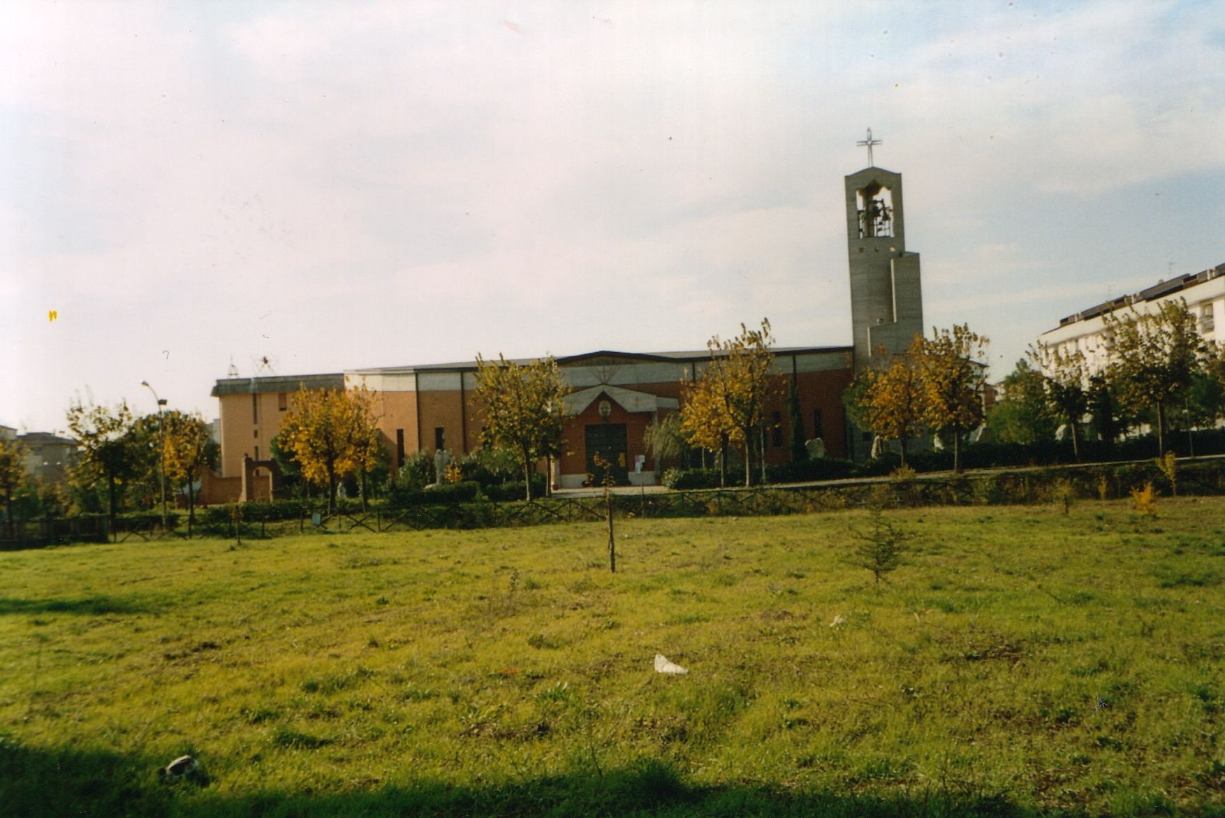
Il quartiere Olmo di Riccio è ad est di Lanciano, alla fine di Via del Mare, in un’altra zona secolare che faceva parte della Valle S. Giusta, una supercontrada che ne racchiudeva diverse. Il nome Olmo di Riccio deriva da una leggenda che si perde nella notte dei tempi circa un conte Riccio che probabilmente faceva parte di quella potente e nobile famiglia locale che si rese protagonista della faida nei primi trent’anni del sedicesimo secolo a Lanciano, ed un olmo posto nel mezzo delle sue terre (nell’attuale Via Olmo di Riccio) ad un centinaio di metri dell’attuale chiesa parrocchiale del Sacro Cuore. L’olmo nei tempi medievali era il punto d’incontro delle discussioni e delle relative decisioni prese in una sorta di democrazia cittadina ed esso, di norma, si trovava di fronte ad una chiesa che era quella di S. Giusta, documentata dall’anno mille e ristrutturata nella forma attuale nel 1860. Lo sviluppo di questa riposante zona cittadina era stato previsto dal piano regolatore del 1958, che voleva ampliare gli orizzonti periferici cittadini insieme con l’estensione dell’altra area suburbana di Viale Cappuccini-San Pietro. La sua realizzazione fu alquanto celere nei disboscamenti di quella che era un’area prettamente campagnola e nella costruzione delle case popolari e di ville negli anni 1960-63, nel nuovo quartiere cittadino Olmo di Riccio. La chiesa del Sacro Cuore è al centro del quartiere e ne costituisce il principale punto di riferimento. Una lapide posta nella parte inferiore del muro, dietro la porta a destra, ricorda l’inaugurazione del 28 gennaio 1990.
by Maurizio Angelucci - Foto-Photos by Nicoletta Di Ciano
|
|
|